
Extreme weather events struck India on 99% of days between January and September 2025 alone — a genuinely staggering figure that killed over 4,000 people and displaced 5.4 million citizens in 2024, the highest displacement number since 2012. Home to one-sixth of the world’s population on just 2% of its landmass, and framed by the Himalayas to the north and coastlines stretching over 7,500 kilometers on three sides, India sits at a genuinely unique intersection of geography that makes it vulnerable to nearly every category of natural disaster simultaneously.
| Rank | Disaster | Share/Scale | Most Affected Regions |
| 1 | Floods | 46% of all disaster events | Ganga basin, Assam, Bihar, UP |
| 2 | Cyclones | 5,700+ km coastline exposed | East coast (Bay of Bengal), Gujarat |
| 3 | Droughts | 68% of land susceptible | Rajasthan, Maharashtra, Central India |
| 4 | Earthquakes | 58-60% of landmass prone | Himalayan region, NE India, J&K |
| 5 | Landslides | Rising with heavy rainfall | Himachal Pradesh, Uttarakhand |
| 6 | Heatwaves | Increasing frequency/intensity | North, Central India |
| 7 | Cloudbursts/Flash Floods | Growing in Himalayan states | HP, Uttarakhand |
| 8 | Cold Waves | Winter months annually | North India |
| 9 | Tsunamis | Coastal, low frequency, high impact | Tamil Nadu, Andhra Pradesh coast |
| 10 | Forest Fires | Seasonal, dry regions | Uttarakhand, parts of central India |
1. Floods — India’s Most Frequent Disaster
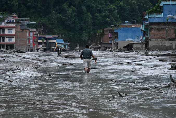
Flooding is genuinely the most common disaster category in India, constituting 46% of all recorded disaster events and contributing the highest overall economic loss.
- Floods affect an average of 5 million hectares out of 40 million flood-prone hectares across the country annually, with roughly 3,000 square miles flooding every year.
- About 12% of India’s total land area is flood-prone, concentrated particularly in the Ganga basin, Assam, Bihar, and Uttar Pradesh.
- A single flood event typically impacts around 3 million people, though the widespread, recurring nature of flooding means cumulative annual impact is genuinely enormous.
2. Cyclones — The Second Most Recurring Threat
- Storms rank as India’s second most frequent disaster category after floods, with approximately 5,700 of the country’s 7,500 kilometers of coastline prone to cyclones.
- The East coast is particularly vulnerable, facing cyclones and coastal flooding during two distinct windows — May to June and October to November — driven by systems forming in the Bay of Bengal.
- States most frequently affected include Andhra Pradesh, Odisha, West Bengal, and Tamil Nadu along the Bay of Bengal, along with parts of Maharashtra and Gujarat facing Arabian Sea-origin storms.
3. Droughts — Less Frequent, But the Deadliest
- Although droughts account for only about 3% of India’s total recorded disaster events, they cause the highest number of fatalities and people affected of any disaster category.
- A single drought event impacts an average of 75 million people — more than the combined population of California and Texas — compared to roughly 3 million affected by a typical flood.
- 68% of India’s total land area is susceptible to drought, reflecting how widespread this vulnerability genuinely is across the country’s agricultural regions.
4. Earthquakes — A Genuinely Widespread Seismic Risk
- Roughly 58-60% of India’s landmass is prone to earthquakes of varying intensity, a considerably larger share than many people realize.
- The Himalayan region and intra-plate fault zones represent the areas of strongest earthquake activity, with Seismic Zone V — the highest-risk category — covering Northeast India, Jammu & Kashmir, and Uttarakhand.
- The 2001 Gujarat earthquake stands as a stark historical example, causing massive loss of life and extensive infrastructure damage.
5. Landslides — Increasingly Tied to Extreme Rainfall
- Landslides have become genuinely more frequent in recent years, closely linked to heavy rainfall events intensified by climate change.
- Himachal Pradesh and Uttarakhand have experienced particularly frequent cloudburst-triggered flash floods and landslides in recent seasons, reflecting the Himalayan region’s growing vulnerability.
6. Heatwaves — A Rapidly Intensifying Threat
- Rising global temperatures are genuinely fueling more severe and frequent heatwaves across India, turning what were once occasional extreme events into recurring seasonal threats.
- The India Meteorological Department (IMD) now issues dedicated heatwave warnings alongside cyclone and heavy rain alerts, reflecting how seriously this threat is now tracked.
7. Cloudbursts and Flash Floods
- A genuinely distinct and increasingly common phenomenon specifically in mountainous Himalayan states, where sudden, intense rainfall triggers rapid flash flooding with minimal warning time.
- These events have become a recurring feature of recent monsoon seasons in Himachal Pradesh and Uttarakhand specifically, often causing significant loss of life and infrastructure damage in narrow river valleys.
8. Cold Waves
- Alongside heatwaves, the IMD also tracks and issues warnings for cold wave events, which affect North India during winter months annually.
- While less discussed than floods or cyclones, cold waves carry genuine health risks, particularly for vulnerable populations without adequate shelter or heating.
9. Tsunamis — Rare but Historically Catastrophic
- Following the catastrophic 2004 Indian Ocean tsunami, which killed 16,389 Indians due to the country having no warning system, no coastal hazard maps, and no evacuation plans at the time, India fundamentally transformed its disaster preparedness infrastructure.
- Tamil Nadu’s Nagapattinam district alone lost 6,051 people, with entire fishing villages disappearing in that single event.
- In direct response, India established INCOIS (Indian National Centre for Ocean Information Services) in Hyderabad, now capable of issuing tsunami warnings within 10 minutes of a major undersea earthquake, alongside the broader Disaster Management Act of 2005 and creation of the NDMA and NDRF.
10. Forest Fires
- Seasonal forest fires remain a recurring concern, particularly in dry forested regions like Uttarakhand, where accumulated dry vegetation and rising temperatures create genuine fire risk during specific months each year.
India’s Genuinely Escalating Disaster Landscape
- India experienced 47 major disasters in a single year recently, reflecting an increasing frequency that reflects the country’s shift from episodic to genuinely continuous disaster exposure.
- Approximately 85% of Indian land is vulnerable to one or more natural hazards, a figure that underscores just how comprehensively exposed the country is across nearly every hazard category simultaneously.
- NDRF and SDRF (National and State Disaster Response Funds) now release relief funding within 24-48 hours of a disaster declaration, reflecting genuinely improved institutional response speed compared to earlier decades.
- Urban flooding is rising specifically due to unplanned infrastructure growth, while infrastructure fragility more broadly increases both economic losses and recovery time following major disaster events.
The Bottom Line
Floods remain India’s single most frequent disaster by a wide margin, while droughts, despite occurring far less often, cause disproportionately severe human impact, and earthquakes threaten well over half the country’s landmass given its position along active seismic zones. The catastrophic lessons of the 2004 tsunami — which exposed India’s near-total lack of preparedness at the time — fundamentally reshaped the country’s disaster response infrastructure, and understanding which hazards genuinely dominate specific regions helps both individuals and policymakers prioritize preparedness where it matters most, especially as climate change continues intensifying the frequency and severity of these recurring threats.
FAQs
Q1. Which Indian states face the highest combined risk across multiple disaster types simultaneously?
Northeastern states, Himachal Pradesh, and Uttarakhand face compounded risk from earthquakes, landslides, and flash floods together, given their Himalayan geography and seismic zone classification.
Q2. How quickly can India now issue a tsunami warning compared to 2004?
INCOIS can now issue tsunami warnings within 10 minutes of a major undersea earthquake, a dramatic improvement from having no warning system at all in 2004.
Q3. Why do droughts cause more people to be affected despite occurring far less frequently than floods?
A single drought event impacts an average of 75 million people across wide agricultural regions, compared to roughly 3 million affected by a typical localized flood event.
Q4. Is climate change genuinely making India’s natural disasters worse, or is reporting just improving?
Both factors contribute, but data shows genuine increases in extreme weather frequency and displacement numbers, reflecting real intensification rather than just better tracking.