
Jamnagar’s identity runs on several parallel tracks simultaneously. It is Saurashtra’s largest city, the district headquarters of one of Gujarat’s most geographically distinctive coastal zones, the home of Reliance Industries’ twin refineries at Motkhana — together constituting the world’s largest single-location oil refinery complex — and the historic city developed by Maharaja Kumar Shri Ranjitsinhji whose urban planning legacy gave Jamnagar its circular road layout and the Lakhota Lake at its center. On the western tip of the Gulf of Kutch, it functions as a commercial and administrative hub for the surrounding Saurashtra coast while also serving as the gateway city for pilgrims heading to Dwarka — one of the four sacred dhams of Hinduism — approximately 130 kilometres to the west.
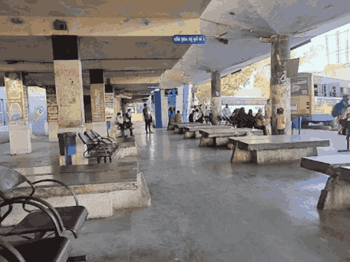
The GSRTC Bus Station in Government Colony, Jamnagar, is the principal public transport terminal for this multi-dimensional city. Positioned on Summair Club Road opposite V.M. Shah Hospital, it operates as the departure and arrival point for GSRTC services connecting Jamnagar to Ahmedabad, Rajkot, Surat, Vadodara, Gandhinagar, Mumbai, Porbandar, and Dwarka. The Rajkot connection is the most commercially significant — Rajkot is 90 kilometres east and functions as Saurashtra’s commercial capital, generating daily business travel that sustains the bus corridor. Private operators significantly supplement GSRTC on all major routes and use the Sat Rasta Circle and bypass zone as their boarding and alighting points, creating a dual terminal geography that first-time visitors need to navigate carefully.
Overview Table
| Detail | Information |
| Name | Jamnagar GSRTC Bus Station |
| Location | Government Colony, Summair Club Road, Jamnagar, Gujarat — 361001 |
| Address Reference | Opposite V.M. Shah Hospital, Summair Club Road |
| Operated By | GSRTC (Primary); Private Operators at Sat Rasta Circle and Bypass |
| Key Routes | Ahmedabad, Rajkot, Surat, Vadodara, Gandhinagar, Mumbai, Porbandar, Dwarka |
| Private Operator Boarding Points | Sat Rasta Circle (MP Shah College Gate); Bypass Jamnagar; Digjam Circle |
| Distance from Rajkot | Approx. 90 km |
| Distance from Ahmedabad | Approx. 300–310 km via NH-48 |
| Distance from Dwarka | Approx. 130 km |
| Distance from Porbandar | Approx. 190 km |
| Nearest Railway Station | Jamnagar Railway Station — Approx. 2–3 km |
| Nearest Airport | Jamnagar Airport — Approx. 5–8 km |
| Bus Types | Volvo AC, Express, Ordinary, Sleeper |
| Governing Authority | GSRTC, Jamnagar Division |
| Notable Feature | Gateway for Dwarka Dham pilgrimage traffic from eastern Gujarat |
Location
The main GSRTC bus station occupies the Government Colony area along Summair Club Road — one of Jamnagar’s important central arterials near the civil hospital zone. The city’s circular road layout, a legacy of Ranjitsinhji-era planning, means most major destinations in Jamnagar are accessible from the bus station without navigating an illogical road grid. Private operators use the Sat Rasta Circle near M.P. Shah College as their primary boarding hub — the seven-road intersection that gives the area its name is one of Jamnagar’s most familiar navigation landmarks.
Directions
From Jamnagar Railway Station: Travel toward the Government Colony area approximately 2 to 3 kilometres, 10 to 15 minutes by auto-rickshaw.
From Jamnagar Airport: Head toward the city center approximately 5 to 8 kilometres, 15 to 20 minutes by cab.
From Rajkot: Travel westward on NH-48 approximately 90 kilometres, 1.5 to 2 hours by GSRTC bus.
From Ahmedabad: Travel southwestward via NH-48 through Rajkot or via Morbi approximately 300 to 310 kilometres, 5 to 6 hours.
From Dwarka: Travel eastward from the sacred shrine town approximately 130 kilometres, 2 to 2.5 hours — the route passes through coastal Saurashtra’s agricultural and salt-pan landscape before reaching Jamnagar.
Connectivity
Jamnagar Railway Station on the Western Railway — handling trains on the Rajkot-Jamnagar branch line connecting to the mainline at Rajkot toward Ahmedabad and Mumbai — provides rail connectivity though the branch line’s frequency and express train options are limited compared to the mainline. Jamnagar Airport handles domestic services including connections to Mumbai, and several airlines serve this route given the refinery industry’s professional population requiring air access. For most daily commuters, GSRTC and private buses remain the primary mobility option.
Nearby Areas
Reliance Jamnagar Refinery Complex: The world’s largest single-location oil refinery cluster is Jamnagar’s most economically significant institution, employing thousands directly and generating an enormous logistics and professional services economy that sustains the city’s commercial vitality. Lakhota Lake and Palace: The historic lake at Jamnagar’s center — with its island palace built by Maharaja Lakha — is among Saurashtra’s most picturesque urban heritage sites. Khijadiya Bird Sanctuary: The wetland sanctuary near the coast recognised as an Important Bird Area supports flamingos, waders, and migratory bird populations, accessible from Jamnagar city.
Frequently Asked Questions (FAQs)
Q1. Where is Jamnagar Bus Station located?
Government Colony, Summair Club Road, opposite V.M. Shah Hospital, Jamnagar, Gujarat — approximately 2 to 3 km from Jamnagar Railway Station.
Q2. Where do private buses board in Jamnagar?
Primarily at Sat Rasta Circle near M.P. Shah College Gate, Bypass Jamnagar, and Digjam Circle — separate from the main GSRTC terminal.
Q3. How far is Jamnagar from Dwarka by bus?
Approximately 130 km, taking 2 to 2.5 hours — a heavily used corridor for Dwarka Dham pilgrims.
Q4. How far is Jamnagar from Ahmedabad?
About 300 to 310 km via NH-48, taking 5 to 6 hours by GSRTC bus.
Q5. Does Jamnagar have an airport near the bus station?
Yes — Jamnagar Airport is approximately 5 to 8 km from the bus station with domestic services to Mumbai and other cities.